
Quetzaltenango
Situated in the highlands, the unofficial ‘capital of the Mayas’.
As my first stop in Guatemala, I wanted a destination that was chill, not too intense, and didn’t require a long travel time - Xela is a 3-hour direct bus ride from Guatemala City. A city full of culture, visitors often come to Xela for homestays and Spanish school. My main draw to Xela was to hike to Laguna de Chicabal, a sacred lake formed in the crater of a volcano. However, walking around the city and just absorbing the atmosphere, the food, the hand-painted shop signs, the live music, it was all so great. If you’re looking for an experience that’s a little different to the well-established tourism infrastructure of many other destinations in Guatemala, I highly recommend paying Xela a visit.
Quetzaltenango (Xela)
I wasn’t aware before I arrived, but Xela is situated at quite a high altitude (not enough to give you sickness though). So I was very surprised to get off the bus from sweaty Guatemala City in shorts and a t-shirt to shivering cold Xela. I actually ended up buying an extra long-sleeve layer from the American clothes store (second-hand clothes), to keep myself warm.
I didn’t have much planned for Xela and enjoyed exploring the city, which was relatively calm and quiet during the day. That is, until you pass through the market streets. Imagine the sounds of sizzling meat, Latin beats, locals holding loud conversations across the stalls, and the calls of people trying to sell you their goods. I wanted to eat everything everyone was selling, it smelt so good.
We stayed in Kasa Kiwi Hostel which is located on the opposite side of Xela from the public transport stops. The hostel wasn’t very busy during our stay, so we got a large dorm room to ourselves. The owners and staff were really friendly and helpful, and allowed us to store our bag and use their facilities after check-out because we were returning from a hike. The hostel had its own rooftop bar, with karaoke every night and a bar food menu. Unfortunately for us, it was raining quite heavily the night of our stay, so we didn’t get to make the most of the view, but it was a popular hangout area with visitors coming from outside the hostel. The facilities were good and in general quite clean.
Things to do in Xela (Quetzaltenango)
Relax in the communal pools fed by natural hot springs at Fuentes Georginas hot springs. Reviews online are mixed.
Challenge yourself with a hike up the tallest volcano and highest peak in Central America, Volcan Tajumulco.
Not ready to take on the tallest volcano? There are plenty more volcanos to choose from: Volcan Santiaguito, Volcan Santa Maria and Volcan Siete Orejas.
Instead of taking a bus or shuttle to Lake Atitlan, consider making a 3-day hike from Xela to Lake Atitlan instead. I wanted to give this hike a go, but didn’t have time.
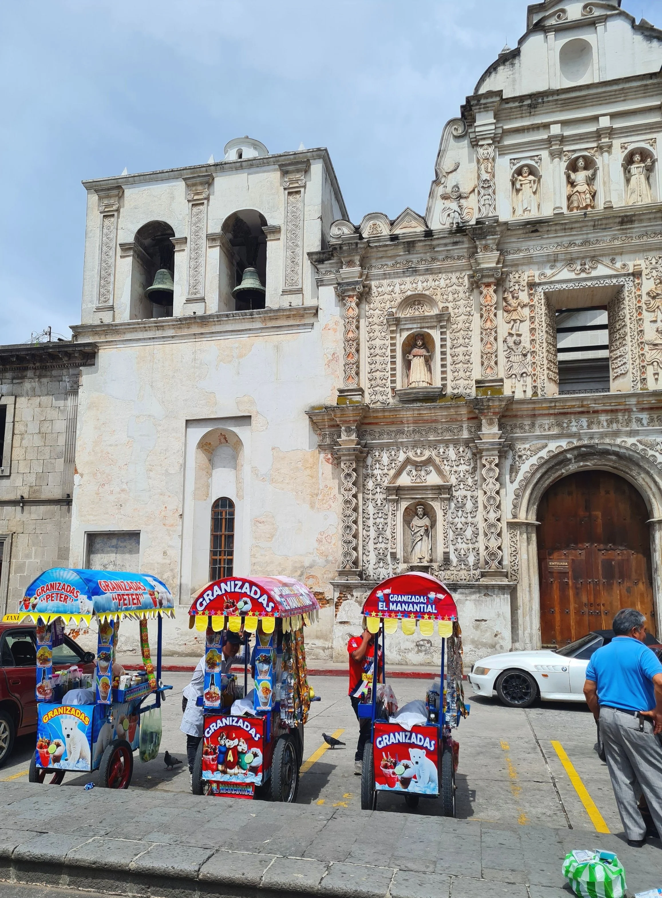
Take in the mix of architecture from grand cathedrals to museums and monuments, colourful single-storey homes to imposing ornate courtyards.
Do not miss a walk through a market. My personal favourite were the stalls along 15 Avenida, because of the street food. For indoor markets check out Mercado de Democracia and Mercado Municipal.


Laguna de Chicabal hike
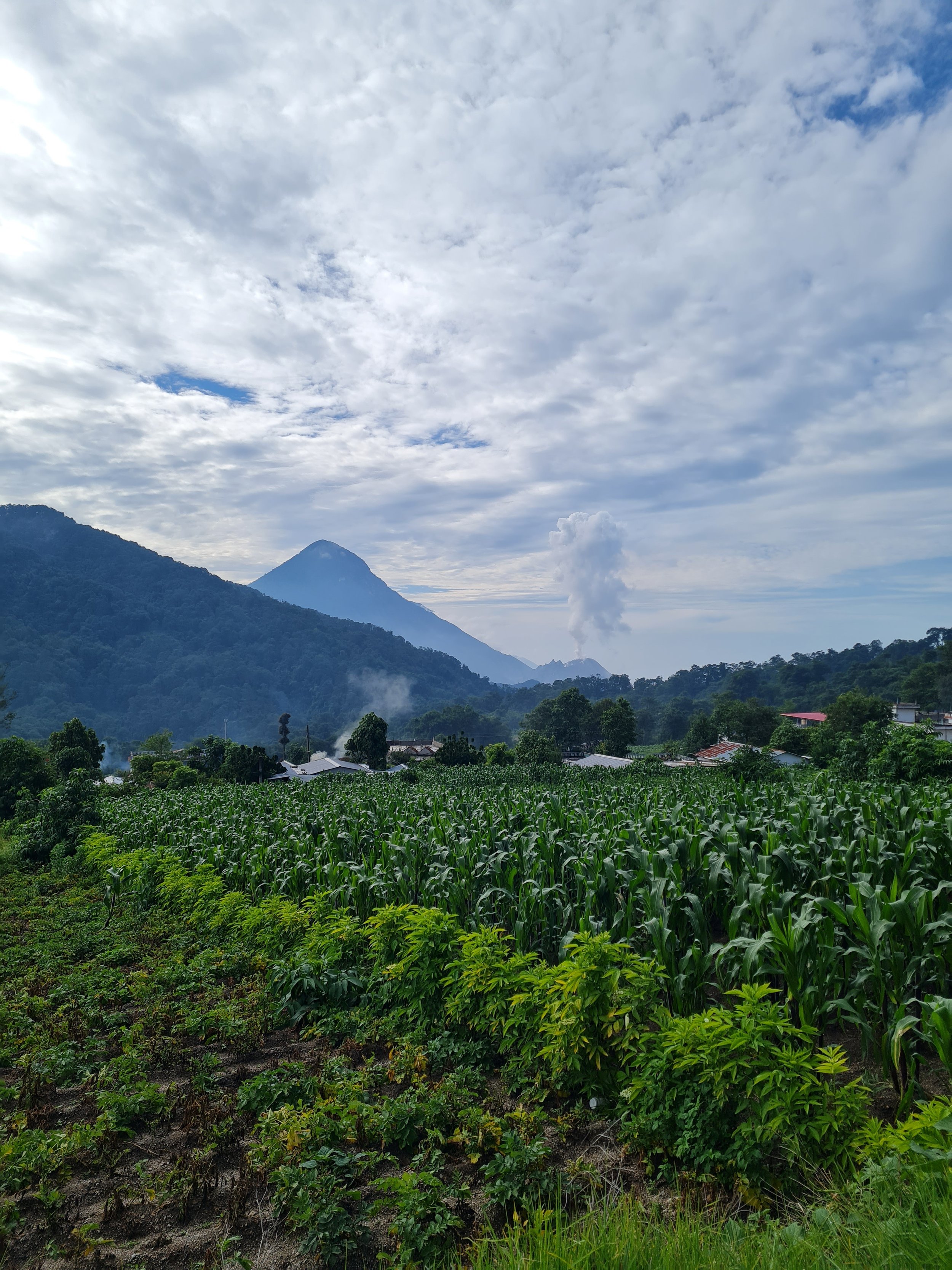
Laguna de Chicabal was created by the collapse of the extinct Volcan Chicabal which created a crater lake. To the Mam Maya people this is a sacred lake, the centre of their cosmovision (the duality between the physical and spiritual world). Because of this, swimming is not allowed in this lake, and you will see several altars on the lake shores.
Laguna de Chicabal needs to be reached in the early morning, ideally before 10am if you want to see it because by late morning the clouds drop and draw in, and the view of the lake is lost. Therefore, this hike requires an early morning start. Luckily, the jet-lag was working in my favour. It is possible to do this hike with a tour, which will pick you up at your accommodation and drive you to a trail head, but I wanted to make my own there using public transport. Making my way to Laguna de Chicabal was an adventure in of itself. I’d found some information online about general directions on how to get there, and this involved catching a collectivo from Xela that would drop you in the town where the trailhead begins.
In order to give us enough time to find our way and then hike to Laguna de Chicabal, we left our hostel at 6am, stopping by the bakery to pick up some breakfast.
Collectivos in Xela all leave from the same place, 6a Calle between 15 Avenida and 16 Avenida. Collectivos will all have their destination and routes displayed on their windscreen, and you can always ask the drivers and conductors which way they are headed. Alternatively, at the corner of 16 Avenida and 6a Calle there is a desk where you can find a conductor standing sometimes who will be able to help you. For Laguna de Chicabal, you want a collectivo that is headed for San Martin Sacatepequez. These will be collectivos labelled Santa Ines, San Martin or Chile Verde. One-way costs 10Q and takes about 40 minutes to get to the central square in San Martin.
Usually, if you are headed to this hike, you get dropped off in San Martin, check out my map to see where to request a stop. From here you can get a taxi that will cut a significant portion of the hike down and take you straight to the trail head. If you choose to walk this section rather than take a taxi, you will be walking about 4km uphill along a cobbled stone road with not much of a view (1-2 hours). We got lucky, and our conductor asked us whether we were planning on taking a taxi or walking up to the official trailhead. When I told him we were planning on walking, he suggested a different stop for us to get off that was along the Santa Ines collectivo route. Again, this is marked on my map. Getting dropped off here means that we skipped most of the uphill climb to the trail head, and it also provided beautiful views. Using Maps.Me, and zooming in on Google Maps, allowed us to see the dirt tracks we could follow to get us to the trailhead. It took about 20-30 minutes to reach.
The official trail entrance has a stand to pay entrance (50Q for international visitors), toilets and a small snack shop. It is also possible to stay the night here in cabins, dorm rooms and camping. From here it’s about another hour hike. The first 2/3rds of this hike is a steep uphill climb, before it levels out to the viewpoint. I found this particularly challenging, I think because I hadn’t had a big breakfast to fuel this hike and was under the heat of the morning sun. I can’t imagine how hard I would have found it if I had done the uphill walk to the trail head as well. (In hindsight, I’d rival this incline to the Acetenango hike, but occurring over a shorter period of time).
I was very happy to reach the view point, which was beautiful, and we reached this around 9am, so in good time to avoid cloud cover. From the viewpoint you can either take steps or a step-free trail down to the water edge and walk around the lake. There were several built altars along the shore, and many flower offerings. Whilst we were walking around the lake, the clouds started to descend, and before we’d even completed a lap of the lake, around 10am, the clouds had covered the water, obscuring all view.
We decided to walk all the way back down into San Martin town to catch a collectivo back to Xela. Once you’d got past the many steps from the lake shore back up to the viewpoint, the trek back down is relatively easy. Since the clouds had come in, the air was a little damper, and the rocky road path that led back into town was a little slippery, so beware. In San Martin, all collectivos will pass by Parque de San Martin, so this is your best bet to catching a collectivo quickly. However, you should also be able to catch a collectivo by waiting wherever you got dropped off, or positioning yourself somewhere along Diagonal 2 will mean that collectivos coming off the main road will pass you. The ride back took 40 minutes and dropped us back in the centre of Xela, where we had originally caught a bus.
We returned to Xela around noon, in time for lunch. Through our hostel we had organised a shuttle transfer to take us to Panajachel, Lake Atitlan that same day. The shuttle would arrive at 2pm, which gave us enough time to grab lunch and have a quick shower before heading on our way.
to Lake Atitlan
View from alternative collectivo drop point
Trail terrain: cobbled road that leads to trailhead, dirt track of trailView point of Laguna de ChicabalShores of Laguna de ChicabalNeed to knows
Unlike other big (tourist) cities in Guatemala, English is not readily spoken here, so come prepared.
Special Recommendations
Food: Albamar Tobogan
Attractions: Market on 15 Avenida
Accommodation: Kasa Kiwi Hostel
R’s take
Don’t leave Xela off your list. Come here to experience local life and Mayan culture, away from big tourism. The area seems busy at night, and feels safe.

Farmland where the collectivo for Santa Ines dropped us off for Laguna de Chicabal trail

Tourist information centre and trailhead entrance
Farmland where the collectivo for Santa Ines dropped us off for Laguna de Chicabal trail

Laguna de Chicabal trailhead entrance

View along the walk to the trailhead from where the Santa Ines collectivo dropped us off

Terrain for the road that leads from San Martin to the trailhead.

Terrain for the main trail

Laguna de Chicabal from the viewpoint

Laguna de Chicabal from the viewpoint

Flower offerings at the shore of Laguna de Chicabal

Steps down to the shores of Laguna de Chicabal

Steps between Laguna de Chicabal viewpoint and shores

Laguna de Chicabal from the shores

10am clouds of Laguna de Chicabal

10am clouds over Laguna de Chicabal

Streets of Xela
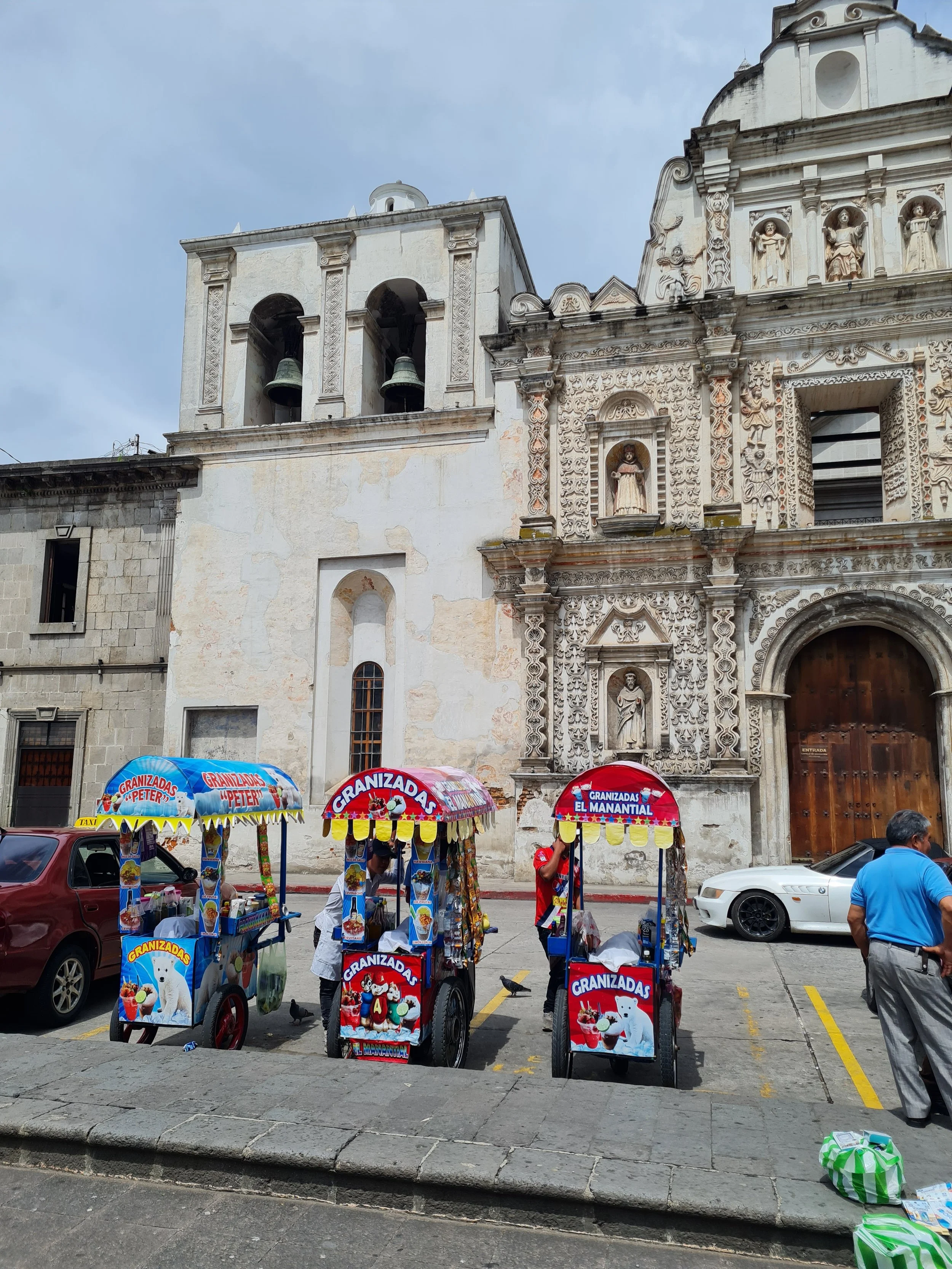
Catedral del Espíritu Santo

Streets of Xela

Bordering farmland of San Martin
How do you pronounce Quetzaltenango?
Quetzaltenango is pronounced: ke-tsal-te-nan-go. It is more commonly referred to by its Mayan name Xela, pronounced: tsel-a or zell-a.
What is the weather like in Quetzaltenango?
Quetzaltenango sits within a valley surrounded by volcanos and has an altitude of 2300m. Because of this, the climate is generally mild during the day and chilly during the nights. Temperatures sit between 6°C - 23°C year round. This will be a surprising change for those visiting other cities in Guatemala, which are much hotter, so make sure to bring some extra layers when visiting here. As with the rest of Guatemala, dry season is very dry, and during rainy season it will rain most afternoons, and occasionally mornings too.
Voted by National Geographic as one of the best places to learn Spanish in the world, Xela has many Spanish schools and private tutors available. Check out some of these non-profit Spanish schools who use the funds to support local social projects in the area: Kamalbe, Sol Latino, INEPAS.
Where can you learn Spanish in Quetzaltenango? (Spanish schools)
When should you visit Laguna de Chicabal?
Dry or rainy season, you still need to make it up to the viewpoint of Laguna de Chicabal by around 10am before the midday clouds start rolling in. In general, during rainy season the mornings still tend to be dry, so it doesn’t matter what time of the year you choose to visit. During my visit in June/July the morning was very cloudy and I was unsure if we’d see anything. But as we started our journey up the volcano, the sky cleared and we had clear blue skies right till the clouds came in over the lake.
Where to stay near Laguna de Chicabal?
Most people stay in Quetzaltenango, the nearest city. I’d recommend staying here as there are plenty of accommodation options to choose from and plenty of services and amenities too. If you’d rather stay outside the city and closer to Chicabal, you can stay around San Martin Sacatepequez. There aren’t many options, but here are a couple recommendations: Reservas del Chicabal, Highland Natural Park or camp at Laguna de Chicabal.
How to get to Laguna de Chicabal?
To get to Laguna de Chicabal you need to make your way to San Martín Sacatepequez. You can do this via taxi, Uber (which you may be able to get from Xela, but unlikely to find a car for return), or collectivo. From Xela collectivos all leave from the same place, 6a Calle between 15 Avenida and 16 Avenida. If travelling by collectivo, look for ones headed towards Santa Ines, San Martín or Chile Verde. Let the driver know that you are headed to hike Laguna de Chicabal, they may be able to drop you off at a location that is closer to the trailhead. Otherwise, get off at the central stop in San Martín, Parque de San Martín. Once in San Martín, you can take a taxi up to the trailhead start - this will cut out the tedious incline hike up a cobblestone road. If you chose to walk this stretch, it should take you around 90 minutes.
Where to eat near Laguna de Chicabal?
There are near to no food options along this hike so come with plenty of water and snacks packed. Along the cobbled road up to the trailhead there is a small shop that sells drinks and snacks. I’m not sure what time they open, so if you start early they may not be open yet, but they were open on my descent down (11am). At the trailhead, where you pay entry to the trail, there is a small and limited snack shop. They didn’t sell drinks when I visited, but they may have just been out of stock. In San Martín, there are more options for food including shops, small eateries, and street vendors, but again these are limited.